 Hi Guest


The Overberg has been explored as early as 1663. The reason for these expeditions was to buy cattle and take it back to Cape Town. These explorers mapped out the Overberg. They attached Dutch names to the rivers and mountains that remain in use today. Corporal Hieronymous Cruse and Ensign Oloff Bergh were the pathfinders. Bergh carved his initials on the wall of the Zieken Huys cave on the banks of the Zonder End River, where periodically he traded for meat. Cruse made his mark in a different way. He kept a diary of this 1669 journey to The Breede River. This journey took 20 days, but this diary is a precious record, because it documents the road of the 17th century cattle-barterers to the Hessequas kraal. Cruse utilized words such as ‘Palmiet’, ‘How Hoek’ and ‘Zonder End River’ in his diary to describe his route to the kraals, as if they were already part of the language. This was indeed the case and Cruse himself helped to put them there.
Schrijver in 1689 followed in Curse’s footsteps. He travelled much further-up to Aberdeen in the Karoo. He took the know familiar road to the Hessequas kraals on the Breede River, but his journals for the first time filled the ‘wagen-weg’ with people and places. While passing down the Zonder End valley towards Tyger Hoek, they noted the thickly-wooded forests of large trees in the mountains on their left-hand side, and the flat country on their right which teemed with wild animals. More than 1000 bonte hartbokken were recorded.
Jan Hartogh’s trip must have been one of the last cattle-bartering expeditions of the old style. The official purpose of this journey, namely to study the flora of the Zonder End valley. Soon after 1707 the Company withdrew altogether from direct trading and farming and relied upon the free ‘burghers’ for its supplies. The resulting boom in agriculture expansion helped to sweep the first wave of white farmers into the Overberg.
Paradoxically, early Overberg colonization benefited by the upheaval in the wake of Willem Adriaan van der Stel. He viewed the Overberg territory as his personal fiefdom. In 1711 Van der Stel named some of his eighteen farms Bot River, Boontjes Kraal, Faisanten Kraal, Warmwaters Kraal(some distance from the hot springs), Swarte River, Sergeants River, Hartenbeesten River, Quartels River, Ziekenhuys, Leeuwen Kraal, Tygers Hoek, de Groote Vlakte, Welgelegen, Rustenburgh and Wytgelegen (a long way from the Cape)-may have been the present day Bredasdorp. The governor, had he chosen, could have covered the 90km distance from the foot of the Houw Hoek Mountain to the Breede River without setting foot on another man’s land. The end came for Van der Stel in 1707 with dismissal and repatriation in disgrace and his farming empire collapsed. But the govener’s activities awakened Cape burghers to the benefits of the Overberg farming and others were quick to copy Van der Stel’s example. Well to do Stellenbosch farmers found that they stood to gain by sending their flocks over the mountains at certain times of the year. During the next seven years burghers were granted ‘leenings plaatsen’ (loan places) allowing them to ‘leggen en wijden’ (squat and graze) over the mountains.
In December 1711 an important party rode out from the Castle on Company business. Willem Putten aided by Hartogh had orders to inspect and assess the forest of the Zonder End valley as a source of timber for the Table Bay settlement. Nothing came of Van Putten’s recommendations for over a decade. Then in 1724 Marthinus Bergh(grandson of the pathfinder who carved his name in the Zieken Huys cave) and Tobias Rhenius(his son would be the first landdrost of Swellendam) were again sent to inspect. Bergh and Rhenius surveyed the forest and studied the trees, identifying yellow wood, stinkwood, assegai wood, pear, alder and half a dozen other varieties.
Soon after, in 1726, a Company post was established at Zieken Huys and they raised the Dutch Flag here. (The Zieken Huys cave: means hospital ) This cave was rediscovered in 1925 by dr Mossop on the farm Nethercourt) Within a year the governer Pieter Gysbert Noodt followed Bergh and Rhenius. He enlarged the River Zonder End post and moving the flag to Zoete Melks Valleij. From here the forest was farmed, animals were bred and fattened for the Cape abattoirs and soldiers were quartered to protect the Hottentot ‘kraals’ and white farmers from the Bushmen and each other.
Other Company posts followed. The first of these lay a little way downstream on the right bank of the River at Tyger Hoek, near present day Riviersonderend. Here they prepared timber from Oliphants Bosch and ran a heard of milk cattle. This post may have been larger than Zoete Melks Valleij. Later the farms Appels Kraal, De Droogte Boom and Bokke River were detached from it.
This history show how the European settler came to the Overberg. It has shown that the infrastructure of occupation was laid and completed within a hundred years of Van Riebeeck’s arrival in Table Bay. Elizabeth Prins in her study of the 18th century found that loan-place grants to white settlers in the western Overberg increased three-fold after the 1780’s. (1730-1779: 53; 1780-1809-135) The two hundred or so white immigrants at that time were the forefathers of the Overberg’s present masters. Nowadays their surnames have a familiar ring: DuToit, Fick, Geldenhuys, Groenewald, Linde, Morkel, Moolman, Otto, Swart, Wessels.
The first colony of Europeans in the Overberg was planted along the Zonder End River. The boundaries of their colony were the banks of the river in the lower 40km of its course (Greyton to Stormsvlei-where the Zonder End river ends). After 1720 there was an influx of residents who saw the Overberg-and particularly the Zonder End Valley-in a different light. They discovered, not merely well watered grazing lands for cattle and sheep but also dense forests of usable timber and fertile soil for cultivating crops.
Riviersonderend was established in 1922, when Ms Edith McIntyre sold her farm Tierhoek for 6 000 pounds to the church council, for the establishment of the local Dutch Reformed congregation. The total of the land purchased was 619 morgen at 6 470 pounds. At first the they wanted to name Riviersonderend ‘Nuwedorp’ (New Town), but the older residents wanted the name Rivier Zonder End. (from the Hesseque word: Kanna-kam-kanna – water, never ending water)
The church decided to loan 4000/ 5000 pound from Theron(the attorney who handled everything) J.T. Mossop, land surveyor, was appointed to survey the plots of the town.
On 27 September 1923 the first auction was held to sell the plots. People who bought these plots were allowed to keep a cow (for milk) and two oxen. Only butchers were allowed to keep sheep. Buyers of these properties were allowed 4 months for down payment without interest. There were 200 plots on the auction and 123 were sold for the amount of 6 230 pound. The plots were sold for about 50 pound each.
The second auction was held on 12 September 1925. On this day 40 plots were sold for 1 950 pounds. According to history Riviersonderend consist of 359 morgan of Tierhoek, 260 morgan of Olifantskloof and 30 morgan of Bego (originally part of Tierhoek).
The Overberg District’s population grew by 2.5 per cent per annum from 205 945 people in 2001 to 232 590 people in 2006. Between 2006 and 2010, the region’s population is expected to increase at an average annual rate of 1.9 per cent to 251 201 people. The population of Overberg DM is quite young, with 68 per cent of the population aged 39 years and below.
Theewaterskloof LM: The Theewaterskloof Local Municipality has the largest geographical area in the Overberg District. It covers areas such as Villiersdorp, Grabouw, Botrivier,
Caledon/Myddleton, Genadendal, Greyton and Riviersonderend. The key administrative and
economic activities are located in Caledon. TWK LM is part of the Project Consolidate
municipalities as they experience numerous service delivery and capacity constraints. The
TWK LM local economy grew at the slowest rate (1.8%) compared to the other LM in the Overberg and the economy is predominantly agrarian.
Cape Agulhas LM: Cape Agulhas LM is situated in the northeast of the Western Cape Province. The LM comprises of the towns of Napier, Bredasdorp, Struisbaai, Elim, L’Agulhas and Waenhuiskrans/Aniston. Cape Agulhas LM has been classified as a low capacity municipality with the majority of the population (83%) residing in urban areas. The LM has a well diversified economy, with a long established, but slowly growing manufacturing sector and agriculture, forestry and fishing dominating the inland areas, and coastal areas that also offer tourism potential. The LM has low levels of formal education and skills levels in their
labour market.
Overstrand LM: The Overstrand LM covers areas such as Hangklip/Kleinmond, Greater Hermanus, Stanford and Gansbaai. Overstrand LM has been classified as a high capacity municipality. Hermanus is the administrative centre of the Overstrand LM and makes a large economic contribution in terms of tourism, fishing, aquaculture and agriculture. The Overstrand LM is a major growth point for the Overstrand District. The local economy grew faster than the ODM at a rate of 3.4% per annum in 2004. The economy is largely driven by the Wholesale and retail trade sectors.
Swellendam LM: Swellendam LM is the second largest municipality within the ODM in
relation to geographical area. The Swellendam LM has been classified as a low capacity LM. The Swellendam LM is the second smallest in population size (30 180) with a slightly
lower average than the district in population growth. In terms of sector contribution in 2004, the largest sectors were Agriculture (22.6%), Wholesale & retail (20.4%) and Manufacturing (12.6%). There is a large problem regarding unemployment amongst the youth and those with an incomplete secondary education.
Overberg District Management Area (DMA): The Overberg District Management Area was constituted after the 2001 Local Government Elections. The DMA covers approximately 60800 ha with a coast line of approximately 70 km stretching from Waenhuiskrans to
Infanta. The area comprises of the Overberg Test Range, the Air Force Base and the De Hoop Nature Reserve.
Adjacent municipalities
• Cape Winelands District Municipality (north)
• Eden District Municipality (east)
• Indian Ocean (southeast)
• Atlantic Ocean (southwest)
• City of Cape Town (west)
In the May 2011 local elections, the DA again won Overstrand outright, taking fifteen of the twenty-five seats on the council, with the ANC taking nine and the National Independent Civic Organisation one.
Overberg literally means 'over the mountain' and it derives from the early settlers in Cape Town who went over the mountains by ox and wagon to see what was on the other side. They found a fertile coastal belt which now is intensively farmed with fields of wheat and herds of sheep. Some considerate farmers have even put signs up on the edges of their fields to tell travellers what kind of crop they are looking at. The villages and towns are all quite charming, some nestling amongst the mountain ranges and others in lowland river valleys.
The Overberg coast, also called the Whale Coast, has the distinction of splitting the oceans. At Cape Agulhas, the southernmost tip of the continent, the waters are cleaved into the Indian and Atlantic Oceans. The foothills of the mountains, covered in a wealth of indigenous fynbos, roll down through green and gold wheat and sheep country to the lighthouse here. Apart from the cry of seagulls and the endless beat of the surf along a holiday-friendly shoreline - which also gives rest to the wreckage of scores of luckless ships - silence prevails and solitude is easy to find.
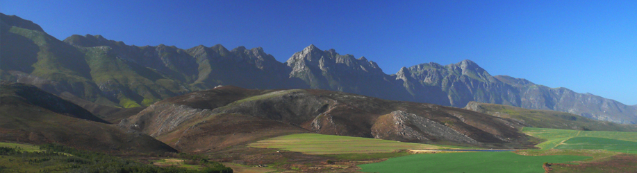
The region is characterised by stunning mountain ranges, a large rolling inland plateau and a costal plateau and part of the Karoo landscape to the north. Tourism is a major driver of economic activity in Overberg District, which is also known as the ‘Golden Gateway’ to the famous Garden Route.
The ODM is predominantly characterised by undulating plains and hills stretching from the Langeberg and Riviersonderend mountains in the north to the Atlantic and Indian Ocean coasts in the south. The fairly flat coastal zone rises from sea level to an average altitude of 100 m. The inland coastal plateau, which includes the Ruggensveld, lies at an altitude of 150 to 300 m. The Klein-Karoo area surrounding Barrydale occur at an altitude of 600 m.
Towns
Arniston/Waenhuiskrans
Arniston is a village where time has stood still; where the practices of generations of fishermen quietly continue without interruption. But this sleepy little coastal town has seen its fair share of drama.
The name Arniston comes from the British transport/hospital ship that sank near the coast in 1815. The HMS Arniston was carrying 378 pasengers (mainly wounded soldiers as well as women and children) and was sailing from Ceylon (Sri Lanka) back to England when it hit a reef. Only six passengers survived the ordeal.
Barrydale
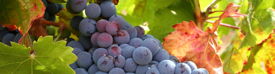
Barrydale is indeed the Gateway to the Overberg and Klein Karoo. Today the timeless countryside charm welcomes you with the friendliness of its people. Sunny days prevail for most of the year, with a little frost in winter. As the valleys are filled to the brim with fertility and the excellent climate, it makes Barrydale a winemakers' dream with premium wines and brandy produced here.
Betty's Bay
Betty's Bay is a coastal town situated between Kleinmond and Pringle Bay. Just off the R44 lies the Harold Porter National Botanical Gardens . This piece of land was bought in 1938 to preserve its beauty for future generations. Lovely walks can be taken here and there is also a restaurant within the Gardens that could be visited for light meals or drinks.
A visit to Stoney Point is a must. This is a breeding colony to the Jackass Penguin. You can take a stroll along the boardwalk and watch these cute little birds going about their daily business and if you are lucky you might spot a whale or two swimming in the ocean too!
Botriver
To the average visitor, Botriver might seem dull and boring, with nothing to do. Au contraire, my friends. This sleepy little town is fast on its way to becoming a mecca of activity. The movie production company Studio City has just signed a thirty year lease in the area and claims that it will become one of the largest companies in the country!
Until such time, though, there are multiple draw-cards for this little village.
Besides the horse-riding, hiking trails and quad biking, there are also wine tours to take. With no less than twelve wine farms in the Botriver District, your choice is endless.
Bredasdorp
Bredasdorp is an agricultural town in the heart of the Overberg – known as South Africa's first “dorp”. The rolling hills surrounding the town are home to many sheep which are farmed for their wool. Wheat is also farmed on a large scale.
The area lays claim to the De Hoop Nature Reserve which covers 60 000 hectares of endangered fynbos. This reserve is home to South Africa's largest population of Bontebok and also the endangered Mountain Zebra. An ideal spot for game viewing and birdwatching (South Africa's national bird, the Blue Crane, can be seen too).
Caledon
Caledon is known as the 'Capital of the Overberg'. Even though to some it is a simply another town along the N2, it does lend itself to some extraordinary history. Lying a mere 120 km from Cape Town heading towards George, it owes its origin to the hot water springs on the slopes of the Klein Swartberg.
The hot mineral baths today form part of the Caledon Casino Hotel & Spa, an elegant establishment, known the world over for its warm hospitality, well appointed conference centre, a variety of sporting amenities, beauty clinic and excellent personal service.
Elim
As you are travelling along the winding road towards Napier through the Overberg, you turn right down a dusty dirt road, heading towards Elim. This quaint little village is found half way between Gansbaai and Bredasdorp – definitely off the beaten track!
On entering Elim, the historical charm of the town will be immediately evident with the lime washed cottages and fig trees welcoming you.
Gansbaai & Surrounds
Danger Point Peninsula - an area ruled by the sea and floral abundance. It is here where you will find South Africa's only town boasting the “Big 2”.
Between the working fishing village of Gansbaai and the secluded ocean community of Buffeljachtsbaai, there is an area to explore that is full of secret wonders.
Gansbaai is an area of contrast. It is situated in the centre of a number of small bays with miles of unspoiled beaches, nature reserves with over 1500 species of Fynbos, ancient Milkwood forests, rocky inlets, caves and spectacular views across Walker Bay. It is a well-known whale watching and great white shark viewing destination.
Genadendal
Welcomed by a timeless feeling when entering this town, Genadendal ('Valley of Grace') was established in 1738 by George Schmidt, who was sent by the United Brethren (Moravian Church) to preach the Gospel to the Khoi people. The focus of the town is the museum complex, which lies in nearperpetual shade under gracious oaks.
The Moravian Church is known for its talented choir and brass band performances. Mission Museum, Genadendal's museum collection has been declared a National Cultural Treasure and is definately worth a visit.
Grabouw
Grabouw is one of the most scenic areas in South Africa with a beautiful mountain range and diverse fynbos vegetation.
For hiking enthusiasts there are many trails to pick from, ranging from day hikes to more gruelling ten day hikes. These include kloofing, cliff jumping and navigating some of the many mountain pools.
Greyton
The charm of this town is immediately evident upon driving down the narrow streets. The cottages which line the roads were built by semi-skilled labourers when Greyton was first established as a little agricultural village some 150 years ago.
It is an artists mecca, with its many trees and country ambience. Horses and oxen still draw ploughs and cars share the roads with donkey carts.
Hermanus
Hermanus is built along the beautiful shores of Walker Bay. The official whale watching capital of the world and a popular holiday destination, Hermanus is surrounded by majestic mountains, indigenous fynbos and spectacular natural beauty. Its residents are the heart and soul of the town, however, providing an unforgettable holiday experience.
Known as the heart of the whale coast, this coastal resort offers the best land based whale watching in the world. Southern Right Whales visit Walker Bay from July until December every year.
Kleinmond
Kleinmond has grown form a holiday destination to a vibrant little town. This is no surprise as it has beautiful beaches (Kleinmond Main Beach repeatedly obtains Blue Flag status), a lagoon, wonderful hikes and walks as well as mouthwatering restaurants.
Harbour Road is the place to be. There are the cutest little shops, awesome galleries and craft stores and the seafood restaurants serve the freshest fish in town. Taking a stroll around here makes you feel like you are on the set of a movie. The wild west meets seaside village.
L'Agulhas
Cape L'Agulhas is the southern most town in Africa where the Indian and Atlantic Oceans meet. For this reason it is a prime tourist destination. L'Agulhas also boasts the oldest working lighthouse in South Africa, which has an interesting museum to visit.
This coastline is extremely ominous and many ships have floundered here. L'Agulhas gets its rich heritage from the shipwreck survivors of many nationalities who settled in this desolate place. The name L'Agulhas means Cape of Needles (referring to the jagged rocks of the coastline and also the fact that a compass shows no real deviation between true north and magnetic north at this spot).
Malgas
This is a sleepy town situated on the banks of the Breede River. Each little house which lines the banks of the river has its own jetty and motor-boat. The river is recognised as the best fishing estuary in South Africa and is also home to an abundance of bird species and wildlife.
Malgas is home to the only river ferry in South Africa, which serves as a vital link between the east and west bank communities of the Breede River. Taking a trip on this pontoon leaves one with a feeling of nostalgia and also in awe of this incredible river.
Napier
This beautiful little town was originally seen as an “Afrikaans Dorp” but has in the recent years established itself as an “Artist's Community”- thought of as a “Second-Greyton”.
Many of the old houses have been bought by city dwellers and been lovingly restored to their former grace. With its narrow streets and quaint architecture, Napier is a town full of charm. Along the main road you will find many restaurants, galleries and interesting little shops. I would recommend trying some of the local “Patat-koek”, a yummy cake-like pudding made out of sweet potatoes.
Onrus
This peaceful little coastal village is situated just outside Hermanus, a perfect escape from this busy town, but a mere five minute drive away. Onrus is called home by many famous artists and authors who revel in the tranquil lifestyle this village has to offer. Nestled between the mountain and the ocean and with the Onrus River flowing into the lagoon at Onrus Beach, this sleepy hollow is exceptionally beautiful with an abundance of wildlife and bird species calling it home. It also beckons the Southern Right whales who visit the ocean meters from shore. The arrival of the whales also brings forth the annual Kalfie Fees in August. A festival celebrating art, music, good food and wine.
Pringle Bay
Pringle Bay is a quiet coastal village in the heart of a UNESCO World Nature Reserve. The area is renowned for its Indigenous Fynbos Flora and houses more plant species per square meter than anywhere else on the planet. On route to the world famous Whale-watching town of Hermanus, Pringle Bay is an ideal place to view whales during the Whale Season from June to December every year.
Riviersonderend
Riviersonderend is a small farming community which developed out of a service to the farms in the surrounding area. It has a very peaceful and rural atmosphere with cattle and sheep lazily roaming the green pastures. The mountain water is brown in colour (caused by organic plant material) and originates from the southern slope of the Riviersonderend mountains. It is believed to be the purest drinking water in this country.
There are many beautiful walks and hikes to take and nature lovers will delight in the breathtaking views across the valley.
Stanford
Stanford is a sweet little village just outside the coastal town of Hermanus. It is full of charm and was established as a farming community. The roads are narrow and the majority still gravel. The houses are full of character and many have been restored to their former glory.
The Kleinriver passes through Stanford and his home to an abundance of birds and wildlife. There are boat cruises and kayak trips down the river and it is probably the ideal spot for birdwatching. During the month of October there is an annual Bird Fair. Sunset is the ideal time to spot birds, so why not take advantage of the Sunset Cruise, where you can sip on a drink whilst floating down the magical river.
Struisbaai
Struisbaai is situated just four kilometers from Cape L'Agulhus (the southern most tip of Africa, where the Atlantic and Indian Oceans meet). The beach here is exquisite, with an almost subtropical feel. The water is crystal clear and its brilliant colour is exaggerated by the colourful boats which reside in the harbour. There is a lovely little seafood restaurant at the harbour where you can dine on some freshly caught fish whilst watching the picturesque scene of the locals bartering with fishermen for their daily catch.
Suurbraak
There is no doubt that SUURBRAAK on the R324 is one of the most beautiful villages in the Western Cape. It was not called Xairu (“Beautiful” or “Paradise”) by the Attequa Tribe for nothing. Situated 250km from Cape Town, 20km northeast of Swellendam (N2), 32km west of Heidelberg and 24km southwest of Barrydale (over the magnificent Tradouws Pass) the historical village, with its 3000 residents, nestles snugly under large oak trees next to the Tradouw/Buffeljags River and almost overpowering Langeberg Mountains (1500m). The town was established in 1812 as a missionary station. The people live close to the ground and some still cook on wood stoves. Local Lawn Services are provided by roaming animals…The historical cottages, Information Centre, churches, shops, clinic, Municipal offices, Library, Post Office, Police Station, crèche and Community Hall along the Main Road will always form the backbone of most activities, but the many upgradings and new building projects in the town reflect that more and more jobs are being created by and for locals and nature lovers settling in the side streets.
A cheese factory is in the pipeline.
Swellendam
Swellendam is a lush town at the foot of the Langeberg Mountains. Many of the buildings in the oak lined streets are colonial and Swellendam is the third oldest town in South Africa. With a moderate temperature the gardens are green and luxuriant and walking through the streets of this town is a joy.
The Buffeljachts Dam allows for much entertainment. Taking a sunset cruise on the sparkling water aboard a fully kitted-out double decker wooden raft is an unforgettable experience. A catering service is available and a braai on board can also be arranged.
Villiersdorp
Otherwise know as “The Pearl of the Overberg”.
This town was given the name De Villiers Dorp in order to reflect the French influence of its early inhabitants (many were descendants of the French Huguenots). Thus much of the architecture is colonial and the streets are lined with towering oaks and a variety of fruit trees.
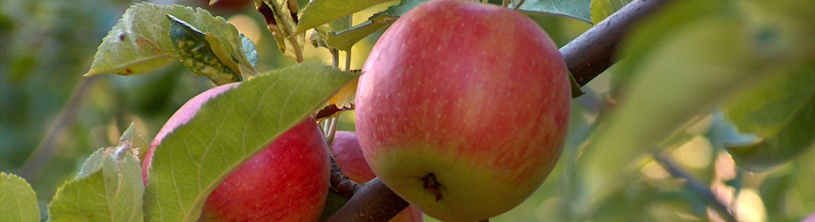
The climate is Mediterranean and this allows for many outdoor activities and also plays a huge role in the fruit farming industry. This beautiful village is surrounded by orchards and vineyards and is also very near the Theewaterskloof Dam which is a source of endless entertainment.
Witsand & Infanta
Witsand is a little seaside resort situated at the mouth of the Breede River. It has unspoilt beaches and a small harbour from where you can go sailing or fishing. This is regarded as one of South Africa's top fishing locations and offers spear-fishing, deep-sea and river-fishing, as well as fly-fishing and snorkelling.
It is also an ideal swimming spot with 4km of unspoilt beach leading to well known Moodie's Well. Parents with small children prefer the calm swimming areas along the river's banks and can also enjoy canoeing trips and river cruises.
The Overberg has a maritime climate, with moderately hot summers, and mild to chilly winters. It is one of the nicest all-year-round rainfall areas in South Africa, most rain falling in the winter months, brought by the humid sea-winds from the Indian Ocean rising and releasing their precipitation along the high mountain ranges just inland of the coast.
Spring: (September to the end of November)
Temperate, minimum 12 degrees Celsius, maximum 22 degrees Celsius – glorious!!!
Summer: (December to the end of February)
Warm to hot, minimum 14 degrees Celsius, maximums between 24 and 34 degrees Celsius,
often cooled by strong winds. Very little rain.
Autumn: (March to the end of May)
A wonderful season. All 3 months temperatures are temperate. Minimum 12 degrees Celsius, with maximums of 22 degrees Celsius.
Winter: (June to the end of August)
Pleasantly cool, with minimums of about 6 degrees Celsius and maximums between 14 and 22 degrees Celsius.
Grain and wool are the two sturdy main pillars of the Overberg's economy with fishing at Gansbaai, protea and onion farming, fruit orchards, vineyards, dairy and cattle farming all contributing to the region's prosperity.
The Overberg District economy contributed 2.4 per cent to the Western Cape’s regional Gross Domestic Product (GDPR1) in 2004 and grew at an average annual rate of 2.4 per cent between 1995 and 2004, lower than the provincial average annual growth rate of 3.4 per cent.
The sectoral distribution reflects an economy that, although fairly well diversified, remains dependent on agrarian activities.
The agricultural sector contributed 21.1 per cent of Overberg’s total GDPR in 2004. Major agricultural activities range from wheat, barley, dairy, and lamb production to deciduous fruit production.
Overberg District is fourth largest economy in the Western Cape, which contributed 2.4 per cent or R3.3 billion of the total Western Cape GDPR in 2004. Within the Overberg District, Theewaterskloof LM is the largest economy, which contributed 41.0 per cent or R1.37 billion of Overberg’s GDPR in 2004.
Overstrand LM is the second largest economy, which contributed 31.0 per cent or R1.04 billion of Overberg’s GDPR in 2004. Swellendam and Cape Agulhas economies contributed 14.1 per cent and 13.7 per cent of Overberg DM’s GDPR respectively for the same period.
The sectoral distribution reflects an economy that, although fairly well diversified, remains dependent on agrarian activities. Economic activity in Overberg is predominantly driven by the Agricultural, forestry & fishing sector, which contributed 21.14 per cent of GDPR in 2004. In terms of contribution to total GDPR, the share of agricultural activities has marginally declined by 1.1 per cent between 1995 and 2004. Grains and deciduous fruit farming mainly drive the agricultural sector. The grain based economic belt, is the mainstay of growth and development in the areas such as Caledon, Swellendam and Bredasdorp.
The major challenges to this sector are global competition, a result of the liberalisation and
deregulation of grain markets in South Africa. The impact is mainly felt in the wheat market whose short-term outlook is not bright due to current surpluses in the market. However, there are prospects in this sector, barley farming for malt production in ‘lager beer’ is a lucrative crop in Overberg, due to the rapid growth in the beer industry and the opening up of African markets. There is also expected growth in the hops industry due to expected high demand for beer.
The Overberg District also boosts a deciduous fruit fringe, which stretches from around Grabouw, northwards intersecting with the Winelands and eastwards including Villersdorp and Barrydale, which intersects with the fruit farming areas of the Breede River. This sector/area has experienced more rapid growth (both economic and employment) when compared to traditional agriculture, especially due to growth in fruit exports.
Other important agricultural activities in Overberg District include dairy products, lamb/mutton, wool and onions farming. Farmers in the region are now diversifying and investing in expanding niche markets such as high quality wheat and floriculture, and looking at tourism opportunities such as eco-tourism, guest-farms.
Other major contributing sectors are the Wholesale and retail trade: catering & accommodation (18.6%) and Finance & business services (15.0%) and Manufacturing (15.1%) .The Wholesale and Retail trade sector increased its contribution substantially by 5.9 per cent and Finance & business services (2.1%) between 1995 and 2004 while the share of the Manufacturing sector declined by 3.5 per cent during the same period.
General Government services declined by 4.6 per cent. On the other hand, the District has limited Construction (5.4%), Electricity & water (1.9%) and Mining (0.1%) sector activities.
The only significant contribution to the Western Cape economy is done by the Agriculture, forestry & fishing sector, which contributed 11.0 per cent in 2004. The Construction sector is also marginally important. It contributed 3.5 per cent of Construction output in the Western Cape. Meanwhile, the Mining, Transport & communication and Finance & business services sectors contributed less than 2.0 per cent to the corresponding Western Cape sectors.
Tourism
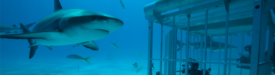
Undoubtedly the major tourist attraction of the Overberg is whale watching. While whales can be spotted throughout the Overberg coast during the Winter and Spring months, the towns of Hermanus and Gansbaai is renowned to be one of the best land-based whale watching spots in the world. The other big attraction in the area is the Great White Shark which can be viewed from boats and for the more adventurous, up close from a cage, doing shark cage diving.
There are a number of well-known vineyards in the area which is well worth a visit to do some tasting.
The Overberg is home to three major reserves to protect the biodiversity of the area. The Kogelberg reserve offers some wonderful hiking trails and white river rafting. At the De Hoop reserve you have a choice of many activities, including small-game viewing, mountain biking, snorkeling and land based whale watching. The Bontebok National Park was proclaimed to protect the last few remaining bontebok - a beautiful antelope that is found only in the Western Cape.
Other activities in the area include river rafting and canoeing in the Breede River, paragliding, sea kayaking, and deep sea fishing.
The Overberg Municipalities are dedicated to promoting local economic development and tourism and to this end has committed itself to increase basic service capacity, massive investment in infrastructure and sustainable growth, the creation of a safe and healthy environment, the management and conservation of the natural environment and the provision of democratic and accountable governance.
The main contributors to the Overberg's thriving economy also include the commercial farming of abalone and the harvesting of aquaculture, the hospitality industry, the wholesale and retail industry, finance and business sectors, manufacturing, agriculture, real estate development and the building industry. The wine industry in this unique region is enjoying substantial growth with approximately 28 wine estates producing award winning labels.
Population figures currently stand at 73 000 and are conservatively estimated to have reached 80 000 by 2010 in the Overstrand. The Overstrand is the second largest municipality in the Overberg and is expected to be the most populous region in the district before long. The Overberg contributes 34,4% (R1,22 billion in 2006) to the Overberg regional GDPR and is currently the second largest contributor.
There are more than 30 Education centres in the Overberg. This includes many public and private schools.
Hermanus
Hermanus has excellent private and government schools and includes:
• Hermanus Pre-Primary
• Hermanus Primary
• Hermanus High school
• Hermanus Montessori
• Bosko Christian School
• Berghof Pre-Primary
• Northcliff House College
• Hermanus Christian Academy
• the Overstrand Learning Academy
• Kidz Academy
• Mt Pleasant Primary
• Lukhanyo Primary
• Qhayiya Secondary
• Waldorf
• Hawston Primary
• Hawston Secondary
• Curro Private School
A bus service for scholars is available. Most of the Hermanus based schools offer dual medium classes in either English or Afrikaans. The schools in Zwelihle are the only Xhosa schools in the Overstrand, while the language of instruction at schools in Mt Pleasant and Hawston is Afrikaans.
There are 15 police stations in the Overberg area and the total reported crimed in the last year amounted to 13 301.
Please note: This list only includes Businesses for sale in the Western Cape and not Franchises. Please click on the following link to view complete list of Franchises for sale in the Western Cape.
Please click here to view complete list of Franchises for sale in the Western Cape